

Arrowsmith CPR Regional Trail
This historic trail was built in 1912 by the Canadian Pacific Railway for visitors staying at the Cameron Lake resort. Starting from Highway 4A, the trail winds through forest, follows a loop route, and ends near a former ski hill below Mount Cokely.
Trail Length
Cameron Lake trailhead to lookout viewpoint:
- One way: 4.8 km, 2 hours, 800 m elevation gain
- Round trip: 9.6 km, 4 hours
Cameron Lake trailhead to Mt. Cokely trailhead:
- One way along east side of loop: 7.5 km, 4 hours 1000 m elevation gain
- One way along west side of loop: 7.8 km, 4 hours, 1000 m elevation gain
- Round trip along full loop: 15.3 km, 7 hours
Trail Difficulty
This recreational trail is rated ‘More Difficult’ and visitors should use it at their own risk. Trails with this rating have many steep sections and moderate continuous slopes, footing is uneven and obstacles are frequent. Suitable for people with a moderate level of fitness. The trail leads to backcountry alpine terrain where cold winds, fog, rain, hail and snow may begin without warning. Be prepared for all weather conditions.
Trail Etiquette
Dogs
For the enjoyment and safety of all trail users, please ensure your dog is under your control at all times, meaning:
- the dog remains in your line of sight
- can be brought to heel by calling
- does not annoy or injure other park users.
If you cannot keep your dog under control it must be restrained by a leash.
Waste
There are no waste bins at the trailhead or along the trail. Pack out all garbage, including dog waste bags.
Be prepared. Stay Safe
- Call 911 for emergencies
- Report all signs of a wildfire. Call *5555
- Report poachers. Call 1-877-952-7277 (RAPP)
What to do
How to get there
Parking is available in the BC Parks Cameron Lake Picnic Area located at the east end of Cameron Lake on Highway 4, as well as alongside eastbound highway shoulder. Park well clear of the highway traffic. Remove all valuables from your vehicle.
Park Map
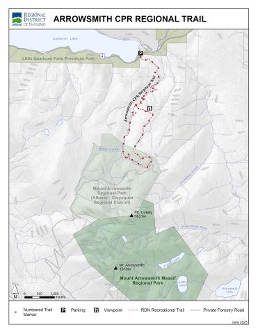
Parks Map PDF Version