

Mount Benson Regional Park
Perched on the northeastern slopes of Mount Benson, this 292-hectare regional park protects a vast forest landscape, important watershed areas and the iconic natural backdrop to Nanaimo. From the summit, hikers are rewarded with sweeping views of the Salish Sea, Nanaimo and Vancouver Island’s mountain ranges. The park contains the headwaters of Witchcraft Lake, Westwood Lake, the Millstone River and the Chase River, highlighting its important ecological value. Access is via the Benson View Regional Trail, a challenging route with steep and rough sections.
Hiking Trail Length
Most direct route from parking lot to summit: 3.5 km
- One way: 3.5 km, 2 hours, 700 m elevation gain
- Round trip: 7 km, 4 hours
The first 2 km of the trail is outside of the park in a Crown woodlot. After the first 2 km, there are multiple route options to the summit of varying difficulty.
Hiking Trail Difficulty
This recreational trail is rated ‘More Difficult’ and visitors should use it at their own risk. Trails with this rating have many steep sections and moderate continuous slopes, footing is uneven and obstacles are frequent. Suitable for people with a moderate level of fitness. The trail leads to backcountry subalpine terrain where cold winds, fog, rain, hail and snow may begin without warning. Be prepared for all weather conditions.
Mountain Biking
From the Benson View Road parking lot, the Outer Bypass trail on Crown land can be used to access the Westwood mountain bike trail network. Mountain bikers can view the trail network and trail difficulties on the Trailforks website, where the Nanaimo Mountain Bike Club manages up to date trail information.
Dogs
For the enjoyment and safety of all trail users, please ensure your dog is under your control at all times, meaning:
- the dog remains in your line of sight
- can be brought to heel by calling
- does not annoy or injure other park users.
If you cannot keep your dog under control it must be restrained by a leash.
Waste
There are waste bins at the Benson View Road parking lot and trailhead. Pack out all garbage, including dog waste bags.
Be prepared. Stay Safe
- Call 911 for emergencies
- Report all signs of a wildfire. Call *5555
- Report poachers. Call 1-877-952-7277 (RAPP)
What to do
How to get there
From Highway 19, take Jingle Pot Road to Kilpatrick Road. Kilpatrick Road turns into Benson View Road, where you can find the parking lot.
Park Gate Hours
The gates at the Benson View Road parking lot are closed during the night. Refer to the Park Gate Hours posted here.
Park Map
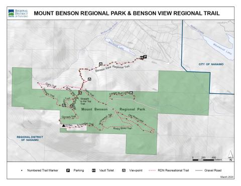
Parks Map PDF Version
Park Management Plan